Note for teachersThis activity will allow students to explore the European Atlas of the Seas’ map layer showing 2022 European Maritime Day in My Country events by navigating virtually from the Baltic Sea to the Adriatic Sea! Through hints provided in this boat race guide and by answering questions, they will progressively discover different events taking place across the European sea basins and sail closer and closer to the race’s finish line where a surprise awaits them! The boat race is a fun interactive way to find out about European Maritime Day in My Country events and to learn how to use the European Atlas of the Seas. This boat race (Level 1 – New skippers) is aimed at first time skippers. Already an experienced skipper in the Atlas? Get ready for the next challenge with the other boat race (Level 2 – Experienced skipper, coming soon)!Competences developed with this activity: map reading, digital literacy, geographic information analysis
Learning to navigate
First things first! Let’s learn to navigate in the European Atlas of the Seas. To do this, watch the video tutorial that will show you how the Atlas works and what tools you can use during the boat race.
Preparing for the race
What do you already know about boat racing? Have you heard about the Vendée Globe and the Route du Rhum for example? Do you know skippers who have participated in these boat races? Share your experience with the class.
Did you know that one of the European Atlas of the Seas Ambassadors participated in the Vendée Globe in 2020? Find out who he is and learn from his experience at sea by opening the map layer on European Atlas of the Seas Ambassadors. How will you find him amongst the 24 Ambassadors? He is the Ambassador for the Finnish language. Did you find him? What is his main message about the ocean?
A boat race must always be well prepared. Safety is essential at sea and you must not forget anything before leaving! Some key steps are listed below.
- Make sure all skippers are well trained, up to date on all safety training and well informed of the navigation route and race rules;
- Prepare the boat: verify and test all equipment carefully;
- Load and store supplies (e.g., food, gear, spares) you will need during the race;
- Check communication and navigation tools; and
- Check the weather and always plan ahead.
As this is a virtual race, here is how you can prepare for the race:
- Open the map layers showing 2022 European Maritime Day (EMD) in My Country events, the country borders and the sea names. The three map layers should overlap each other. You can check this by clicking on the layers’ icon. You can drag and drop the different layers to change the order. Make sure that the top layer is the one showing the EMD In My Country events so that you can see them better. Zoom in on a region and then zoom out. Click on a starfish representing an event to read the description of the event in the window that will open.
- Find a name for your virtual boat. You can take part in the race in teams or solo.
- Check that your Internet connection is stable.
Setting Sail
Skippers must read maps and know about the compass directions. Are you good at this? A little reminder, on the maps you will find the north at the top, the south at the bottom, the west to the left and the east to the right.
On your marks …. Go!
Step 1: Your first challenge is to find out where the boat race starts! Find the location of the two most northern events. In which country is it located? Who is organizing these two events?
Step 2: Navigate south across the Baltic Sea, along the coasts of Denmark and into the North Sea. Stop by the most northern event in the North Sea. When is this event taking place?
Step 3: Head south to the northern coast of Spain. What is the name of the Bay you have reached? You will see three groups of events. Click on the group in the middle. What are the events organized there?
Step 4: Sail further south, along the coasts of Portugal, towards de Strait of Gibraltar and the Mediterranean Sea. Your next stopover is on an island country located south of Italy. Have you found it? Click on the group of events. Click on the arrow in the window describing the events to see all of the events organized on the island. One of the events is a boat tour with a marine biologist. Who is it organized by?
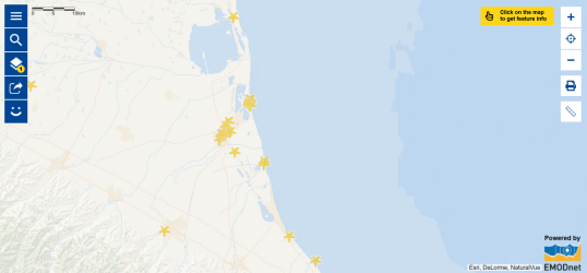
Step 5: Navigate along the Italian coasts across the Ionian Sea and into the Adriatic Sea. Many events are organized there! You have almost reached the final destination of the race… Find the area in the north of Italy where you can see the highest number of events. Zoom in to see the map below.
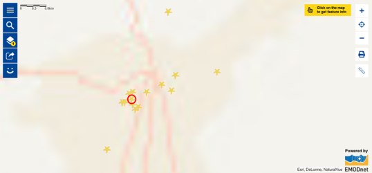
Zoom in again several times until you see the map below and click on the starfish in the circle in the Atlas (the name of the event is ‘Ravenna, giornate del mare’).
Welcome in Ravenna! You have just passed the finish line! Make sure you download your diploma!
While you are in Italy, discover the projects of the Italian members of the Network of European Blue Schools! Open the map layers Network of European Blue Schools and country borders. How many European Blue Schools are there in Italy? Click on the pieces of the puzzle representing the schools to learn more about them. In the window that will open, click on the name of the project to see what students have been working on. Would you like your school to join the Network of European Blue Schools? Read how you can apply online!
We hope you have enjoyed the journey! To learn more about the ocean and seas, we invite you to learn about the other events shown in the map. By clicking on each starfish, you can access the websites related to the events or the organisers of the events. Have fun!


