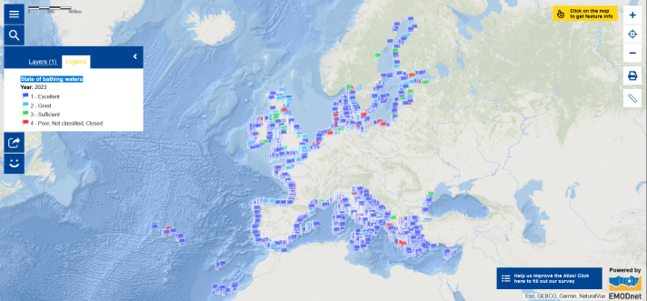
Summer is here! Did you know there is a map layer on bathing waters in the European Atlas of the Seas? You can explore the Map of the Week and zoom in on a specific area to see the quality of the bathing water at beaches along the European coasts. If the flag is dark blue or light blue, the state of the bathing waters is respectively excellent or good. Green flags indicate sufficient water quality. Red flags highlight poor water quality or waters that are not classified in any categories. Before you dive into the sea, dive into the map to check the status of the water. By clicking on the flag, you can see additional information including the name of the beach, the geographical coordinates, the status of the waters and the year of evaluation of the status of the waters. By clicking on the arrow in the top right-hand corner of the window proving the detailed information for each flag, you can see the status of the waters in different years.
In a recent briefing, the European Environment Agency stated that, from the Atlantic to the Mediterranean, most of Europe’s bathing waters are of excellent quality for swimming when assessed against the two specific health relevant parameters (Escherichia coli – or E. coli – and intestinal enterococci) as required under the Bathing Water Directive (European Union, 2006). In 2023, at almost 22,000 locations, 85% of bathing waters were rated excellent, while 96% of waters met the minimum quality standards required for compliance with the Bathing Water Directive, a slight increase compared with the previous year. However, 1.5% of the European Union’s bathing waters are of poor quality, indicating that management measures are not always adequate or in place. Pollution of surface and groundwater remains significant, and may be exacerbated by the changing climate. Improving water resilience for people and for the environment in coming years will be key. [1]
We can all contribute to improving water quality, water management and the state of the environment we live in. This summer, learn about the following campaigns and initiatives and participate for a healthy ocean and waters!
- Dive into the #WaterWiseEU campaign to see water differently!
- Make sure that you are not leaving any litter behind on the beach and participate in #EUBeachCleanup 2024 events!
And, learn more about the ocean!
- Test your knowledge with the European Atlas of the Seas’ quizzes and games;
- Dive into the Atlas and zoom in to explore the region you live in or the region you are travelling to. Change the basemap to ‘Cities template’ to see more details and select different map layers (e.g. Marine Natura 2000, maritime museums, public aquariums);
- Discover pioneers of change in Ocean Literacy by reading about the MakeEUBlue Awards 2024 winners;
- Learn about the EU4Ocean Coalition that connects diverse organisations, projects and people that contribute to Ocean Literacy and the sustainable management of the ocean and find out how you can join the more than 1,000 members by becoming a member of one of the three communities, the EU4Ocean Platform, the Youth4Ocean Forum and the Network of European Blue Schools!
The Map of the Week will be on a summer break in the coming three weeks. We will be back with new ocean and seas updates on 2 August 2024!
The data in this map are provided by EMODnet.
[1] https://www.eea.europa.eu/publications/european-bathing-water-quality-in-2023/