- Theme
- Atlas Teachers' Corner
- Created on
- 25 April 2023
|
Note for teachers This activity will allow students to learn how to use geographical coordinates to find any specific location on a map. The Atlas’ technical team has hidden three objects in the map layer ‘European Maritime Day in My Country 2023’. The geographical coordinates for the locations where these objects can be found are included in the table below. By using the Atlas’ measure tool (click on the icon representing the ruler on the right side of the screen and select ‘Coordinates’), students can find these locations. They can complete the table to indicate which object they have found at each location, what country they have reached and what event is being organised at this location. There is a common theme to these three objects. All of these objects are used for a specific purpose. Let the students discuss what the common theme is and indicate it in the table. The virtual geocaching game is a fun interactive way to learn how to use the European Atlas of the Seas and find out about European Maritime Day in My Country events. Ask the student to click on the starfish at each location to get details about the event that is taking place at this location. The game can also be the starting point for further research and discussion based on the questions included below. Competences developed with this activity: advanced use of digital maps, digital literacy, geographic information analysis, research for information |
The Atlas’ technical team has hidden three objects in the map layer ‘European Maritime Day in My Country 2023’. Will you find them using their geographical coordinates?
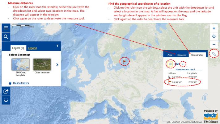
Step 1: Learn how to use the Atlas’ Measures tool to see geographical coordinates
Do you know all of the tools that are available in the European Atlas of the Seas? Do you know how to activate the Measure tool in advanced features? Watch the video tutorial, have a look at the interactive help tool accessible from the Atlas’ menu and review the information below on the Measure tool before you start exploring the map layer!
Step 2: Explore the map layer to find the objects and record your findings
Complete the table below to indicate which objects you have found at each location and indicate, in each case, which country you are in and what event is being organised at this location. To learn about the event, click on the green symbol.
Once you have found the three objects, think about what their common purpose is.
|
Latitude |
Longitude |
Object found |
Notes |
|
53.430000 |
-7.930000 |
Country: Event: |
|
|
40.63209851 |
22.72994803 |
Country: Event: |
|
|
59.329444 |
18.068611 |
Country: Event: |
|
|
Common theme to all objects |
|||
You found all of the objects and the common theme? Well done! You are now an Atlas expert!
Step 3: Learn more!
Go a step further and learn more by finding the answers to the following questions!
- To find the objects in the map, you have used the geographical coordinates of the locations where these objects were hidden. You had the latitude and the longitude. Imagine someone else would like to play the game. Can you explain to them what the latitude and the longitude are and how this will help them find the objects?
- Can you think of three other objects that are related to the same common theme?
- How are these objects used at sea?
- Select one of these objects and explain how it works.


