The Maritime Spatial Planning directive envisages to:
- reduce of conflicts between sectors and creation of synergies between different activities
- encourage investments by creating predictability, transparency and clearer rules
- increase cross-border cooperation between EU countries to develop energy grids, shipping lanes, pipelines, submarine cables and other activities, but also to develop coherent networks of protected area
- protect and preserve of the environment through early identification of impact and opportunities for multiple use of space.
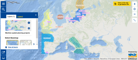
Have a closer look at the map and the information :
- Where do you find the maritime spatial planning projects?
- What is e.g. SIMNORAT? What region does it cover?
- Which directive has been put in place?
- What is the deadline for the establishment of maritime spatial plans?
- What can be the problems for Member States to respect this deadline? What kind of help has been put in place to help them?

