The European Atlas of the Seas’ team is thrilled to introduce the latest addition to the suite of tools, the ‘My Locations’ tool! As you may already know, with over 270 map layers available in open access in 24 languages, the European Atlas of the Seas is a great educational resource for topics such as marine sciences, ocean pollution, climate change, marine biodiversity, and the blue economy. With the new ‘My Locations’ tool, you can expand this map catalogue by creating your own maps showing locations you have selected and saving them in your personal ‘My Maps’ folder.
If you are a teacher, you can for example create map layers to show:
- where partner schools in an educational project are located;
- the locations of field trips or sites that you will visit during a field trip;
- the locations of observations you have made, for example related to marine litter;
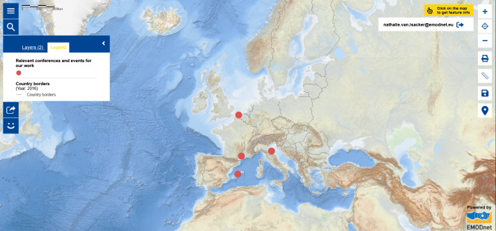
- where conferences and events that are relevant to your work are taking place.
What is ‘My Locations’?
The ‘My Locations tool’ enables you to easily identify and mark specific locations on the map, offering you a customised experience and allowing you to develop maps tailored to your needs. As the maps you will develop with the ‘My Locations’ tool will show your locations, you will have to save them in your password protected ‘My Maps’ space to come back to them later. They will not be visible to other Atlas users.
If you have not yet used the Atlas’ password protected ‘My Maps’ space, watch the ‘My Maps tool’ video tutorial to learn how you can save your maps.
How can you access the new ‘My Locations’ tool?
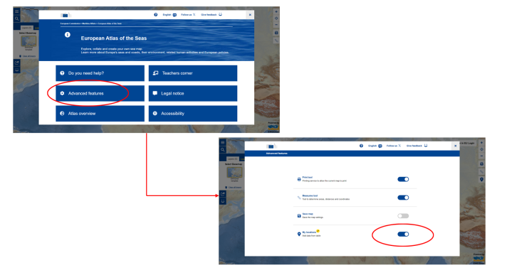
To start using the ‘My Locations’ tool, open the European Atlas of the Seas’ menu, click on the ‘Advanced features’ button and activate the tool.
How does the new ‘My Locations’ tool work?
Once the ‘My Locations’ tool is activated, click on the pin icon on the right side of the screen. A window will open that will allow you to add your locations in two ways you can choose from:
- you can fill the table manually with the geographical coordinates of your locations, the related descriptions and any additional data you wish to include; or
- you can copy your data from an external table.
You can choose which attributes to display in pop-ups, and apply different drawing styles for the legend of your map. When you have done this, click on the button to create your map layer and do not forget to save your new map!
If later you wish to come back to your new map to view it or to update it, open ‘My Maps’, select your map from your personal catalogue and upload it.
If you wish to share your new map with others, you can take a screenshot of the map, use the print tool or use the share tool.
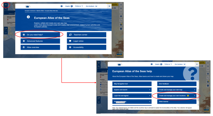
To see a detailed step-by-step demonstration of how ‘My Locations’ works, click on ‘Do you need help?’ in the Atlas’ menu and then select ‘Create and manage your own locations’. You can also watch the video tutorial dedicated to the 'My Locations' tool.
What new possibilities arise with the ‘My Locations’ tool?
The ‘My Locations’ tool marks a significant step towards expanding the ways you can use the European Atlas of the Seas:
- Personalised mapping - Tailor your map layer by adding your locations and relevant details, ensuring a fully customised map with a legend you have designed. Note that you can combine the map layer you have created with existing map layers in the Atlas and save the resulting map in ‘My Maps’. You can also use the tool to show the results of small citizen science initiatives.
- Enhanced teaching - Whether you are studying marine biodiversity, tracking pollution, or teaching about climate change impacts, you can pinpoint key locations on your map to create an engaging educational experience. You can use your map to highlight the location of case studies.
- Customised demonstrations -Combine the use of the ‘My Locations’ tool and the ‘Measures tool’ to create your own map and easily calculate distances between two locations you have marked or between your marked locations and other points of interest on the map. This is especially useful for analysing the proximity of specific features or comparing distances between different locations. Can you estimate the distance between your school and the sea or between your school and the nearest river?
- Saved time and simplified navigation - Create a map layer with locations that are directly relevant to you (e.g. your school, your project partners) that you will always be able to combine with other map layers to quickly see where you are on the map and easily zoom in on your area of interest.
- Ease of Use - If you have collected data during a field trip or a project that has been recorded in table, you can easily copy your data from this table into the ‘My Locations’ tool to create a new map layer and visualise the result of your work.
- Possibility to update and share your maps - Once you have saved your map layer in your personal ‘My Maps’ space, you can further work on it to update it with additional locations or data by adding rows and columns. You can thus continuously build upon your map and show it or send it to your colleagues or students.
What are the other benefits of ‘My Locations’, beyond education?
The European Atlas of the Seas is not just for educators! Whether you are a marine researcher, an environmental advocate, a policy maker, and/or a citizen passionate about the ocean, the Atlas offers accessible and user-friendly tools to explore, analyse, and visualise marine data. Use it to study environmental trends, monitor coastal developments, or gain insights into marine ecosystems and the blue economy. Use the ‘My Locations’ tool to show where your research sites are located, which coastal areas your project is focusing on or where you have carried out beach-cleaning activities!
Get started today!
Ready to explore and create your own map? Log in today to access the ‘My Locations’ tool and discover a whole new way of navigating the maritime world around you!
If you have any questions, us the Atlas’ feedback form to contact the Atlas’ team.
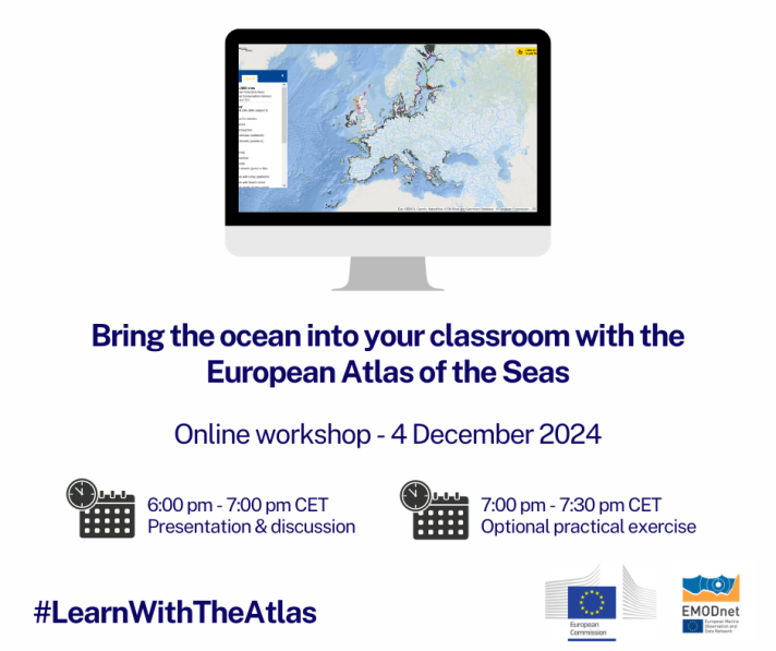
Wish to learn more? Save the date to join the Atlas team on 4 December 2024 for the online workshop ‘Bring the ocean into your classroom with the European Atlas of the Seas’ that will be held between 18.00 and 19.30 (CET). During this workshop, you will be able to learn more about the ‘My Locations’ tool and ask questions. In addition, you will be able to participate in an optional exercise to get hands-on experience. Teachers working with pupils and students of all age groups are welcomed! Registrations will open when the date of the workshop approaches. Stay tuned!