This week, on 25 and 26 April 2024, the Science is Wonderful! science fair organised by the European Commission will gather everyone passionate about science in Brussels. The event will welcome over 100 leading researchers from across Europe and beyond. Participation is open to everyone – school classes, families, fans of science – and is free of charge. Visitors will be able to speak to researchers, participate in hands on activities, interactive sciences shows, games and quizzes at a wide variety of science booths. Topics covered will span, from example, from ‘What can we learn from spiders?’ to ‘Dive into a water treatment adventure with us!’, ‘The Antarctic lab: a trip back in time’ and ‘Oceanographers in Brussels’! Don’t miss the booth n° 6 “Let’s protect our ocean!”. The EU4Ocean Coalition for ocean literacy and the European Atlas of the Seas will be there! We look forward to seeing you!
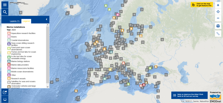
Speaking of research, did you know that the European Atlas of the Seas includes a map layer on marine installations? Europe has an extensive network of marine research infrastructure which incorporates a wide range of facilities including research vessels and embarkable equipment, on-land and offshore research and test facilities in the physical, biological and chemical domain as well as numerous remote and in-situ observation facilities. This map shows the different facilities based on the Marine Research Infrastructures database from EurOcean. EurOcean is an independent, non-profit, scientific organisation with the mission to support advances in European marine science and technology, by fostering information exchange, interaction and innovation among its network members, the ocean community and broader society. Zoom in to see all of the marine installations in a specific area. Click on the map to see the key characteristics for each facility, including links and contacts in order to access further details provided by the operators of these facilities. Facilities included in the map layer include, for example, costal observatories, marine biology stations and research vessels. Check the legend to view the full range of facilities in the map layer.
Wish to visit the ‘Science is Wonderful!’ science fair?
- If you are an individual or a family, you can simply come to the science fair. Registration is mandatory for schools and big groups, register your school or group;
- Prepare your visit by reading the practical details and having a look at the description of the science booths and the floor plan;
- Enjoy your visit!
You cannot visit the science fair but you would like to learn about interesting science activities? Have a look at some teaching resources, games and videos prepared by scientists!
The data in this map is provided by EurOcean.