On 23-24 April 2024, the new Horizon Europe funded project AQUARIUS embarked on its journey with an online kick-off meeting. Comprising 45 partners, AQUARIUS is dedicated to advancing research and innovation activities aligned with the European Union Mission: Restore our Ocean and Waters by 2030 (Mission Ocean and Waters). Encompassing the Baltic and North Sea Basins, Black Sea, Atlantic/Arctic, and Mediterranean Sea, along with their associated major rivers like the Danube, Elbe, Ebro, and the Burrishoole Catchment, AQUARIUS addresses the three primary objectives of Mission Ocean and Waters: protecting and restoring marine and freshwater ecosystems, preventing and eliminating pollution of our ocean, seas and waters, and fostering a carbon-neutral and circular sustainable blue economy. Leveraging 57 research infrastructure services, including research vessels, mobile marine observation platforms, aircraft, drones, satellites, sensors, fixed freshwater and marine observatories and test sites, data buoys, experimental facilities, and data infrastructures, the AQUARIUS project will provide free-of-charge access to these infrastructures via two transnational calls for access, enabling a holistic approach to research and innovation projects.
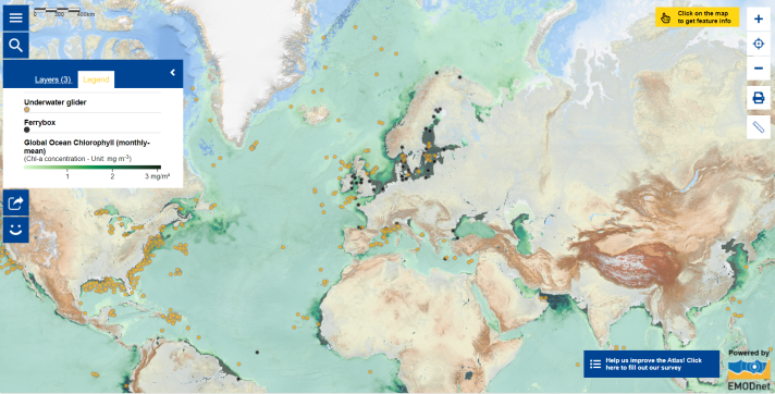
Currently, many existing efforts are contributing to oceanographic research through a variety of research infrastructure facilities and instruments across the globe, including research vessels and embarkable equipment, on-land and offshore research and test facilities. This includes in-situ observations (environmental measurements collected from sea-borne monitoring systems [1]) as well as satellite observations. In the Map of this week, which includes several map layers, examples of two oceanographic instruments are included. Underwater gliders and FerryBoxes play a crucial role in collecting valuable data on ocean parameters.
- Underwater gliders autonomously collect ocean data through the water column by adjusting buoyancy, measuring parameters like chlorophyll concentrations, temperature, salinity and other parameters. This data is then transmitted to shore.
- FerryBoxes are automated surface water monitoring systems fitted to the through-flow system of ships, including commercial and research vessels. Equipped with various sensors, FerryBoxes collect data on physical, chemical, and biological ocean parameters, including salinity, temperature, nutrients, pH, chlorophyll, and more.
Click on the dots in the map that represent these instruments to access further details and see the platform data providing near real time information!
In addition to oceanographic measurements, optical satellite sensors are commonly employed to monitor the health of the ocean environment. The map also features a layer that shows monthly average global surface ocean chlorophyll-a concentration (in mg per cubic meter) during the last month in regions unaffected by cloud cover. This product is provided by Copernicus, derived from multiple optical satellite sensors and calculated using the Copernicus GlobColour processor. Chlorophyll serves as an indicator of photosynthetic plankton abundance, the primary producers in the ocean. The concentration of chlorophyll in a sea region reflects water temperature and nutrient levels. The latter also provides insights into pollution levels.
There are various ongoing efforts in studying the ocean status and addressing urgent global challenges. Through collaboration and the integration of diverse research infrastructures, initiatives like AQUARIUS and other collaborative efforts collectively work towards healthier, sustainable, and protected ocean and waters.
Wish to learn more or participate in European marine observations initiatives?
- Follow the AQUARIUS project development online and stay tuned for the AQUARIUS transnational Access Calls;
- Explore the European Ocean Observing System (EOOS) website to learn about the development of Europe’s diverse ocean observing communities;
- Connect to the European Marine Observation and Data Network (EMODnet) portal to access marine data and information as well as data products;
- read the previous Map of the Week that introduces Science, Marine Research Infrastructures and Ocean Literacy;
- subscribe to the LandSeaLot community.
Looking for a related educational programme?
- Participate in the Adopt a Float education programme to bring ocean sciences to your classroom, where your students can engage in monitoring of the float and its data and learn with ocean scientists!
The data in this map is provided by EMODnet and Copernicus Marine Service.
[1] https://marine.copernicus.eu/explainers/glossary#glossary-term-173