This week, the European Atlas of the Seas attended the conference Join the Blue Schools in the Netherlands. The event organised by the municipality of Den Helder, the Network of European Blue Schools and the European Marine Science Educators Association (EMSEA) brought together about 100 students, teachers, school directors, researchers, education organisations, experts, companies and policy makers. The existing blue schools – Meerwerf Basisscholen Den Helder en Scholen aan Zee – and many education stakeholders – including NIOZ Royal Netherlands Institute for Sea Research, International Polar Foundation, Women4Oceans, Ecomare, Darwin200, Auke-Florian Hiemstra, Ciência Viva, Escola Azul, EMSEA and Vonk - showcased their efforts and work to inspire each other to teach about the sea. Participants learned a lot about how schools can bring the ocean into their classrooms and gained amazing knowledge on a diversity of topics such as the deep sea, cephalopods and the Arctic! The European Atlas of the Seas gave a presentation that highlighted how the Atlas’ Teachers Corner and the new Atlas’ pilot functionality ‘My Maps’ can be used to create new educational activities about the ocean. With ‘My Maps’, teachers can now create their own working space in the Atlas to develop customised activities such as exercises, quizzes and games!
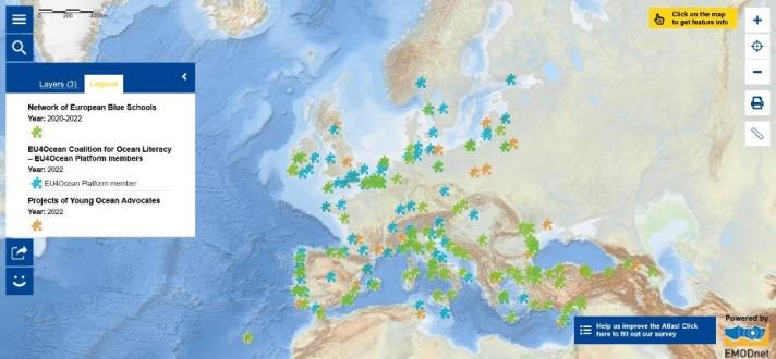
The Network of European Blue Schools is part of the EU4Ocean Coalition together with the EU4Ocean Platform and the Youth4Ocean Forum. It aims to inspire teachers, school directors or staff of education services, to challenge their students, from kindergarten, primary, lower and upper secondary, technical or vocational schools, to ‘Find the Blue’ and develop a project that links them to the ocean or the sea. As the Map of the Week shows, a large number of schools from many countries have joined the Network of European Blue Schools over the past two years. The first European Blue School, Dr.JAC.P. Thijsse Basisschool, was certified in Den Helder by European Commissioner for Environment, Oceans and Fisheries Virginijus Sinkevičius in 2021. A second school in Den Helder was later certified as a Blue school: Scholen aan Zee [1] This first Blue Schools conference highlighted how, via the European Blue Schools program, we can engage our younger generations to get to know the sea and take care of it.
Speaking of the Netherlands, we of course also wanted to mention the Wadden Sea in this Map of the Week! Did you know that the Wadden Sea is listed by UNESCO as World Heritage for its globally unique geological and ecological values? [2] The Wadden Sea is the largest unbroken system of intertidal sand and mud flats in the world. The site covers the Dutch Wadden Sea Conservation Area, the German Wadden Sea National Parks of Lower Saxony and Schleswig-Holstein, and most of the Danish Wadden Sea maritime conservation area. [3]
Wish to know more?
- Get to know the certified European Blue Schools and learn how your school can join the Network!
- Explore the Map of the Week and click on the green pieces of the puzzle to learn more about these European Blue Schools and their projects! Click on the orange pieces of the puzzle to learn about the work of Young Ocean Advocates within the Youth4Ocean Forum and the blue pieces of the puzzle to find out about the activities of the EU4Ocean Platform Members. Use the map to identify partners for your projects!
- Test the new Atlas’ pilot functionality ‘My Maps’! To access ‘My Maps’, click on the magnifying glass and select ‘My Maps’ in the search window. If you wish to first see how it works, dive into the Atlas’ interactive help tool available from the menu (click on ‘Do you need help?’), scroll down to select ‘Create and manage your own map’ and follow the guide! Let us know what you think and how we can improve this pilot functionality by completing our online survey!
- Learn more about the Wadden Sea.
The data in this map are provided by the EU4Ocean Platform, the Youth4Ocean Forum and the Network of European Blue Schools.
[1] https://emsea.glueup.com/event/join-the-blue-schools-den-helder-70887/

