Academic research
Analysis for optimal location of aquaculture sites analysis in Scotland
Analysis of environmental sensitivities offshore north sea.
Application for the 28th Licence Round - Environmental impact assessment part for DECC Alice Gadney - Cartographer -OMV UK 02073331985
Assessment of an invertebrate fishery and supporting ecosystem in the West coast of Ireland
Assessment of MPA network and Marine Habitat Mapping
Assist with research survey design and to contribute to ICES/OSPAR assessment
Atlantic Sea in Azores Investigation
background research for offshore route
Bay of Biscay marine habitat mapping and management
Bonn Agreement BE-AWARE project
Building GIS map of habitats in Severn estuary
Cable feasibility study
Case study cartography to create a MPAs layout.
Characterization of an area.
Combining with VME
Comparison with SNH survey deliverables to resolve apparent discrepancies
Compilation of marine datasets for a strategic Environmental Assessment
Creating marine habitat maps for a 'internal' research project for the UK Royal Society of Wildlife Trusts.
Creating marine habitat maps for a 'internal' research project for the UK Royal Society of Wildlife Trusts.
Data Analysis
Desk based feasibility study
Desk based survey for Natural England
ecosystem service assesmsent severn esyarry and bristol channel
Ecosystem Service Mapping
ecosystem service mapping severn estuary
Educational use
Environmental assessment
Environmental Constraint Mapping
Environmental Consultancy
Environmental Desktop Study
Environmental Mapping
Environmental studies - EIA, ES etc.
Establishing where Eunis habitats are in West of Shetlands
Evaluation environnementale document de planification activit├®s en mer
Figure creation for Department of Environment Northern Ireland by ABPmer.
fisheries
Fisheries
For a sensitivity mapping project within the NE of Scotland
For connectivity assessment of macroalgae
For environmental information on or near project sites and subsea cable routes.
For inclusion in an EIA
For potential usage in European project Turnkey (Atlantic Areas project)
For reference in environmental planning.
for scientific research of the Western Iberian margin
For the web MPA OSPAR (GIS tool)
For use in an ES
For use in GIS projects along with our own fisheries and scientific data.
For use in subsea cable scoping study.
For use on a sensitivity mapping project along the NE coast of Scotland
For use within GIS for offshore windfarm EIA work
Gaining insight in spatial distribution of marine habitat types.
General interest
General planning benthic survey.
geoscience research regarding sound propagation through sediments
GIS work about Marine Protected Areas
Greater understanding for Environment Agency to use in WFD fish classification analysis for estuaries
Habitat analysis
Habitat assessments in Polessie protected areas/IBAs
Habitat Mapping
Habitat Mapping
Habitat Modelling - PhD Research
Habitats Directive assessment compilation of data on the marine environment
I am a PhD student looking into over-wintering wading birds on estuaries and being able to see some biotopes for the mudflat they forage upon would be very useful.
I am currently working on species distribution modelling and I need a lot of spatial data to perform my task. I am a PhD student at IUEM-UBO, Brest, France
I am doing a GIS project on wind farm location to puffin populations
I am doing a proposed research project looking at spatial displacement of cetaceans for an MSc course.
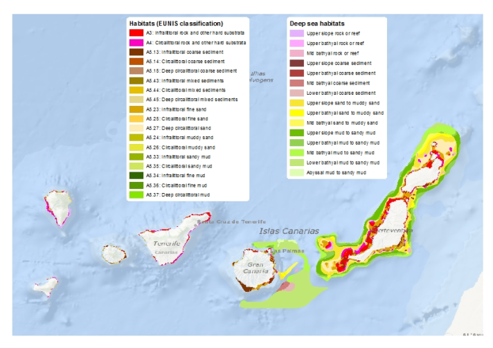
I am mapping marine communities of Canary Islands
I wish to download these data to create and manipulate maps for awareness-raising and advocacy for the Scottish MPA network and the National Marine Plan.
ICES working group
Inform benthic habitat assessment of tidal project in Northern Ireland
Interreg project
Interreg Valmer. North Devon case study
Kent and Essex IFCA habitat survey
Knowledge of possible impacts of trawling in the area.
Learn about the ecosystems that surround drilling platforms through spatial analysis.
LIFE+ Project on MPA in Portugal
local old version corrupted
MAIA project
Mapping in PO
Mapping marine communities of Canary Islands
Mapping of marine ecosystem services
Mapping survey results of the distribution of an invasive sea-squirt Didemnum vexillum in Clew Bay, Co. Mayo, Ireland.
Mapping survey results of the distribution of an invasive sea-squirt Didemnum vexillum in Clew Bay, Co. Mayo, Ireland.
Marine assessment
Marine Mapping Project
Marine protected area proposal and for sampling preparation and planning for PhD.
master thesis
MIS RAZONES
Model of effects fishing in the Celtic Sea
Model of the effects of fishing on several species in the Celtic Sea
Modelling
MPA OSPAR study
MPA OSPAR website
MSc assignment
MSFD analysis
MSFD use.
My PhD aims to model the habitat preference and spatial usage of seals' colonies. For this modelling work, I need environmental variables as sediment and seabed habitat.
Needed to create maps for Celtic Sea Trout Project. The project is part funded by the European Regional Development Fund through the Ireland Wales Programme (INTERREG 4A).
Offshore renewable SEA
Offshore wind farm planning and EIA
OSPAR habitat mapping program
OSPAR use
PhD examining vulnerability of Modiolus habitats across OSPAR areas
PhD project is investigating climate change impacts to Modiolus beds
PhD research
PhD Study: using mapping to scope best areas to protect Irish Sea ray species.
Preparing a tender response and demo for OSPAR
Project Consulting
Project for a GIS class at Scripps Institute of Oceanography.
Project for Northern Ireland Marine Task Force
project on the impact of off shore windfarm on the biodiversity
Quality check
Reference
Research
Research ecological status surrounding oil platforms.
Research for job application.
Research into climatic change effects on marine habitats and species
Research into marine spatial planning
Research into Nature Value and Nature Valuation
Research project
Research purpose
Scientific purposes
Scientific research
scientific research
Scientific research of the habitats in northern Spain
Scientific use to model cetacean and seabird distributions along Portuguese mainland coast
See possible impacts of trawl fishing in the area
Sensitivity map for oil spill response planning
Severn Estuary Mapping project
Shoreline sensitivity mapping
Statistical analysis
student work
study see beds in Azores
STUDY-WORK
Subsea cable feasibility study
To assist authority to comply with the Biodiversity Duty and other regulations and guidance on environmental protection.
To assist compliance with Biodiversity Duty
To be able to describe the dataset as part of a marine data gap analysis for the EC funded EU BON project.
to check habitat locations
To check overlap
to check overlap of habitats and activities
To check overlap with habitats
To compare my data with sediment characterization
to compare with other habitat assessments in the same area
To evaluate whether it can inform assessments of risk to marine ecosystems
To incorporate data in habitat suitability modelling.
To produce overlay with fishing effort map.
To produce overlay with fishing effort map.
To review content
To update our records for NI Marine Conservation Zone designation process
To update our records for the Northern Irelands Marine Conservation Designation Process.
To use the data in future research
To view results of habitat surveys carried out in Northern Irelands inshore and offshore waters.
UK fisheries and environmental management
Understanding the marine habitats around Guernsey
Use in a postgraduate project
Use in Ospar Cobam work
Use in report for First Flight Wind
use in research work and informative
using data to examine vulnerability of Modiolus habitats
Valmer Interreg
We are computing a broad ecosystem map for the sea regions of Europe following EUNIS habitats classification at level 2.
We are currently doing research on ecosystem services delivered by the Belgium North Sea. To calculate biodiversity values we need to have habitat data for specific species and there sensitivity.
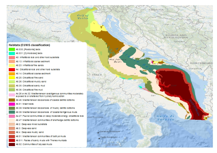
We are currently planning to conduct a coral habitat mapping in the eastern Mediterranean and want to compare our future data with these data.
We are recompiling GIS information related to the Azores Islands (Portugal) for scientific use.
Work on the problem of coastal erosion
Working on a project on support structure of offshore wind turbines
Working on a project related to the impact of windfarm on the biodiversity
Working on Euseamap 2
Working on strategic plan for aquaculture in Ireland


