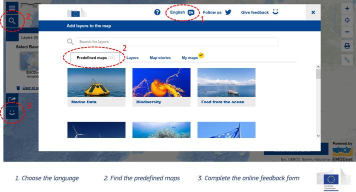
First, discover different oceanographic instruments deployed in the ocean to collect marine data that help us better understand the current state of the ocean. Then, explore the four other maps to address key aspects of sustainable development: biodiversity, food from the ocean, clean energy and climate change. Do you work in different languages? So do we, the maps are available in 24 languages!
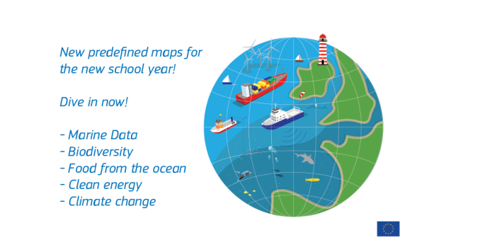
As you may know, the European Atlas of the Seas comprises more than 275 map layers on a wide diversity of marine topics. Several map layers can be overlaid to gain knowledge on the different aspect of a chosen topic. By combining several map layers you have selected yourself, you can create your own map. The Atlas team has done this to create five new predefined maps, combining map layers on the topics of marine data, biodiversity, food from the ocean, clean energy and climate change.
Why? Because these topics are of great importance to better understand how the ocean influences us and how we influence the ocean so that we can take informed decisions in our everyday lives that lead to sustainable development. As such, biodiversity, food from the ocean, clean energy and climate change are important pillars of the European Green Deal and related European Union (EU) policies (e.g., EU Biodiversity Strategy for 2030, Farm to Fork Strategy, European climate law and EU Strategy on Adaptation to Climate Change). These topics are also directly relevant to the sustainable blue economy.
The new maps are available under ‘Predefined maps’ in the Atlas. You can load the new maps to explore them and get more information about these topics by reading the associated texts. Both the maps and the texts are available in 24 languages, making it possible to easily integrate the maps in school work across Europe.
What can you expect to learn from these maps? Below is a short teaser for each topic.
- Marine Data: Ocean observation is key to understanding the current state of the ocean and seas and essential for the knowledge base of the European Green Deal. Explore the map to learn about oceanographic instruments used to collect data, including Argo floats, drifting buoys and High Frequency Radar. See where they are and what parameters they are measuring.
- Biodiversity: Biodiversity is essential for life. Nature provides us with food, health and medicines, materials, recreation, and wellbeing. With this map, become knowledgeable about marine Natura 2000 sites, coralligenous habitats and marine protected areas.
- Food from the ocean: Did you know that EU citizens on average consume about 24 kg of seafood per year? The EU accounts for about 3.3 % of global fisheries and aquaculture production. At the EU level, 80 % of the production comes from fisheries and 20 % from aquaculture. Explore the map to learn about seawater finfish farms, shellfish farms, macroalgae production facilities and microalgae production facilities.
- Clean energy: Clean energy is one of the main pillars of the European Green Deal which aims to make Europe the first climate neutral continent by 2050. The key principles of this policy are to prioritise energy efficiency while developing an integrated, interconnected and digitalised EU energy sector based largely on renewable sources. Open this map to see both clean offshore wind and ocean energy projects throughout European waters.
- Climate change: Climate change impacts the ocean in multiple ways. For example, climate change leads to global increased sea surface temperature which results in sea level rise, changes in species' distribution ranges, abundance and seasonality and coral bleaching. Use this map to find information about sea level change and coastline changes based on satellite data.
Do you have any questions about these maps? Let us know by completing the online feedback form included in the Atlas.
Best wishes to all teachers and students for a great sustainable new school year!