EMODnet progress overview
General progress highlights
On 20-21 September 2022, EMODnet together with the European Commission DG MARE organized an online workshop on “EMODnet marine data for the offshore renewable energy sector in the Northeast Atlantic, North Sea and Baltic Sea”. The workshop was attended by more than 65 offshore renewable energy experts with representatives from diverse sectors including industry, research, policy and marine data services. EMODnet was well represented by thematic experts from physics, biology, geology and human activities, Data Ingestion, Central Portal and the EMODnet Secretariat. More information is available on the Central Portal.
EMODnet Secretariat focused on preparations for the 12th Technical Working Group meeting and EMODnet-Copernicus second coastal workshop, which both held back-to-back on 21-22 September. Both meetings were hybrid events, taking place in Brussels and remotely.
In the reporting period, a new use case was developed in collaboration with Frontex and published on the Central Portal. Frontex regularly uses EMODnet’s vessel density maps, a data product that was first released in 2019 and has been kept up to date ever since.
Specific progress and achievements of the thematic data assembly groups
- EMODnet Bathymetry published several survey datasets from five new data providers, including the Norwegian Hydrographic Service. In addition, data providers are also preparing more High-Resolution Digital Terrain Models (DTMs) and populating them into Sextant catalogue. Validation of each of the regional grids is in process and already shows an enhanced quality compared to those in 2020. This has the effect of improved selection and ordering of the different bathymetric sources. A complete DTM is being generated for the future release of a new full EMODnet Bathymetry DTM coverage, which will include the Caribbean Sea. These Seas are also being included in the Global Terrain Satellite Models (GTSMs), using Best Estimate Satellite Derived Digital Coastlines. Other activities include a review of official coastlines and legal baselines for all countries around Europe. This will include an updating of the inventory of existing and ratified baselines, registered claims/disputes under UNCLOS (United Nations Convention on the Law of the Sea), for the EU and official national coastlines. Efforts are also underway to establish a tidal bathymetry for the Venice Lagoon and to show the impact of bathymetry in this area as a result of storm surges.
- EMODnet Biology published an additional 180,611 occurrence records bringing the total number of records to over 29,9 million. Further work continued in the development of a range of products, which are targeted for publication towards the end of 2022 and the first quarter of 2023. After the development of the EMODnetWFS-package, a new R-package was developed, i.e. EMODnetWCS, which allows users to access metadata and coverage data from all available EMODnet WCS endpoints through R. Specific members of the EMODnet Biology consortium engaged with the OSPAR and HELCOM Regional Sea Conventions; a detailed plan for contact with UNEP-MAP (United Nations Environment Programme - Mediterranean Action Plan) is being developed. The EMODnet Central portal Map Viewer now includes Phase III data products from EMODnet Biology created between 2019 and 2021; six of the products were reformatted to the netCDF file format and were uploaded to the GeoServer and ERDDAP systems.
- EMODnet Chemistry closed the data harvest for contaminant data. Regarding the eutrophication data, for which the harvest closed already the end of June 2022, the six regional coordinators were provided with data packages for their region as well as with lists indicating which datasets were newly added or updated since the previous harvesting round. There is interest from the EU Joint Research Centre (JRC) and DG Environment to engage EMODnet Chemistry as the infrastructure for Member States as part of the EU Marine Strategy Framework Directive (MSFD) to gather the contaminants datasets.
- EMODnet Data Ingestion together with EMODnet Physics continued the collaboration with the ARICE project; data from the Arctic Net and Amundsen were linked and are now available in EMODnet Physics. During this quarter of 2022, 12 new SEANOE datasets have been harvested by the data ingestion service; in total 36 new datasets were received by the Data Ingestion portal. The new activity on improving and documenting the availability of data provided for coastal and offshore licensing has kicked off; a first step consisted of identifying potential stakeholders. In a second step, a baseline Assessment or Inventory of Data Collection and Licensing Processes in each country will be established.
- EMODnet Geology project partners continue their data deliveries until the end of the project, especially for the remote sea areas, Caspian Sea and Caribbean Sea. All new and updated data submitted by the partners are being added to the different data products. Project partner Geological Survey Finland (GTK) took over the responsibility of all Caspian Sea tasks formerly assigned to Russian partner VSEGEI, and is in the process of subcontracting the former Azerbaijan subcontractor of VSEGEI.
- EMODnet Human Activities now also hosts the World Database of Protected Area. This is an entirely new dataset which is global in its coverage and includes coastal and marine protected areas in the European seas. This dataset is fully harmonised with the European Environment Agency’s dataset. Efforts have also been successful to update the freshwater aquaculture datasets for Poland, Scotland, Austria, Belgium, Croatia, Czechia, Norway, Estonia, Slovenia, Spain, Lithuania, Slovakia and Sweden and will be made live soon with new data for production volumes of main species. Existing datasets for the Route Density Maps, have been updated to August 2022.
- EMODnet Physics’ activities focused on making available data products ready and compliant to the needs of the Central Portal. In light of the latter, a complete review of metadata links was done.
- EMODnet Seabed Habitats produced a guidance document aimed at members of the project consortium, which clarifies what is within the scope of ‘coastal wetlands’ for the purpose of the current project contract. A point dataset describing for each year the probability of a certain seabed location in the Baltic Sea being located below the deep halocline has been created; it has a spatial resolution of 5 km and a temporal coverage of 20 years. The thematic lot carried out their second of four six-monthly bulk updates of data to the EMODnet Seabed Habitats portal. The chair of the MSFD Technical Group on Seabed Integrity contacted the thematic lot to discuss queries from Member States about the use of EMODnet products such as the EUSeaMap in MSFD assessments.
EMODnet data portals usage
User visit statistics
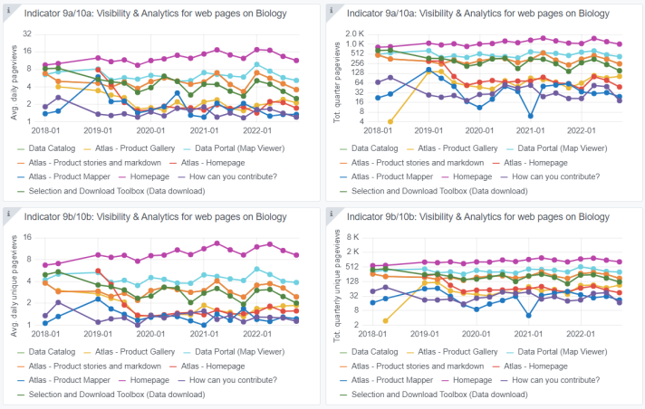
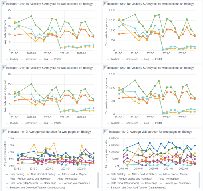
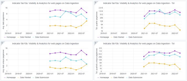
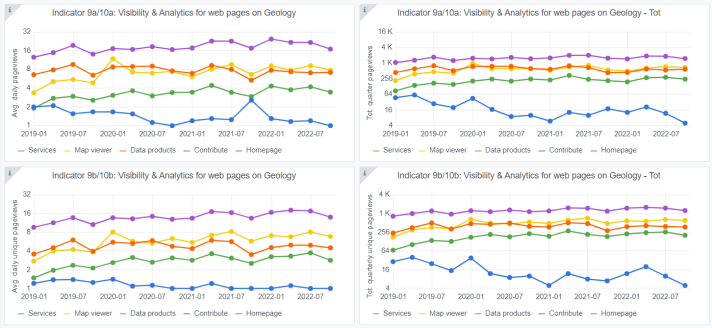
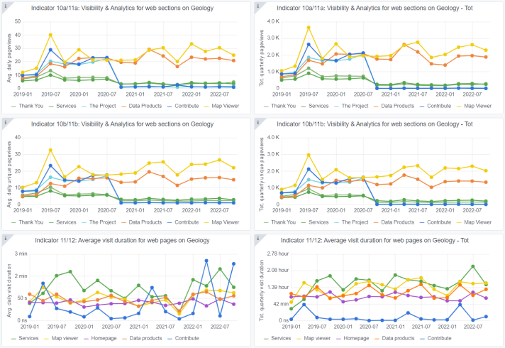
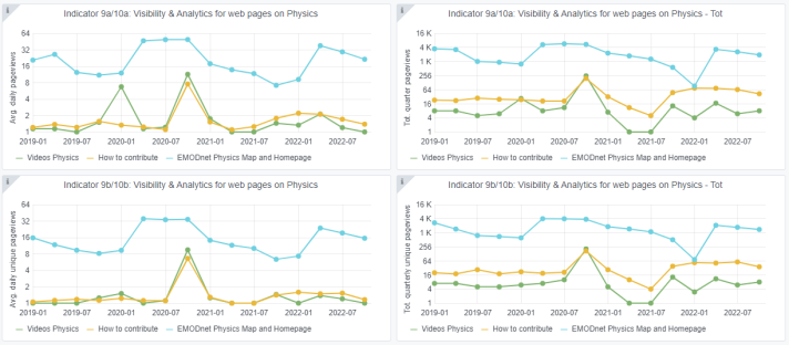
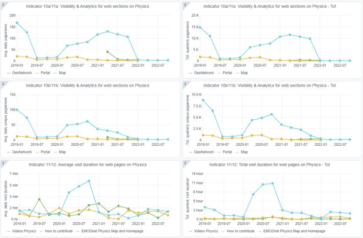
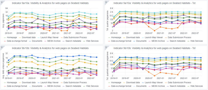
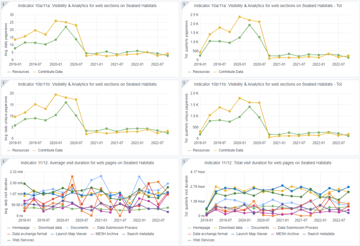
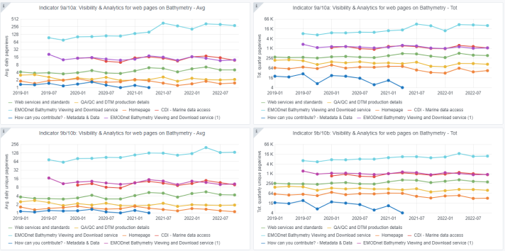
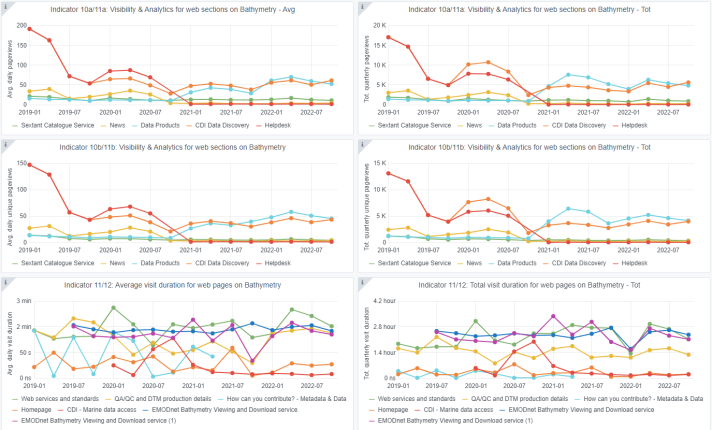
User statistics (i.e. number of ‘unique’ page views and average visit duration) are collected through an EMODnet Matomo instance managed by VLIZ, which is automated for the following progress/monitoring indicators: Visibility & Analytics for web pages; Visibility & Analytics for web sections; and Average visit duration for web pages (note that Matomo will gradually be replaced by ‘Europa Analytics’ as thematic portals are integrated into the Central Portal). The resulting graphs for each EMODnet thematic lot as well as the Central Portal can be viewed in the gallery at the end of this report. Unless stated otherwise, page views and visit durations are average per day and trends are compared to the previous quarter.
- Compared to the previous quarter, the number of average daily pageviews remained fairly constant for the EMODnet Bathymetry webpages; the EMODnet Bathymetry Viewing and Downloading Service remained the most visited webpage (284 pageviews in this quarter). Most time was spent on the Web services and standards webpage (1.7 minutes).
- A slight decrease was observed in the average number of daily pageviews for all EMODnet Biology webpages; they ranged between 1 and 12. Average daily visit durations ranged between 17 seconds and 1.6 minutes; most of the time was spent on the Atlas Product Gallery page.
- Visitors of EMODnet Data Ingestion primarily visited the Homepage (9 average daily pageviews) and the Data Submission service (4), where they stayed for on average 30 seconds and 21 seconds respectively.
- EMODnet Geology observed small dips in the average number of daily pageviews for almost all webpages (numbers decreased by 1-4). Most of the time was spent on the Contribute page (2 minutes).
- The EMODnet Human Activities portal logged 28 average daily pageviews for the Homepage and 76 for the View Data webpage. Most of the time was spent on the latter webpage, with 1.7 minutes.
- Slightly decreasing numbers of average pageviews were observed for EMODnet Physics. On average, the Physics Map and Homepage received 22 daily pageviews, and users spent on average 1.1 minutes on this page.
- Fairly stable trends were observed in the number of average daily pageviews for the EMODnet Seabed Habitats webpages. The Launch Map Viewer received the most pageviews (22), followed by the Homepage (11) and Download data (8). Most of the time was on average spent on the Documents page (2.4 minutes); least time was spent on Search metadata (18 seconds); around 1 minute was spent on both the Data products and Map viewer pages.
Statistics on usage of EMODnet portals[1]
Number of data downloads[2]
- There was a significant increase in number of downloaded CDIs from EMODnet Bathymetry compared to previous quarter, i.e. from 285 in Q2 to more than 187,000 CDIs in Q3.
- Compared to the previous quarter, a small increase was observed in the number of manual data download requests from 192 to 200 on the EMODnet Biology thematic portal, accounting for a total of over 110,000 downloaded occurrence records.
- A considerable decrease of almost 300% was recorded in the number of Common Data Index (CDI) dataset manual downloads for EMODnet Chemistry (from 26,768 to 6,764 CDIs).
- EMODnet Data Ingestion recorded a decrease in number of data download transactions, from nearly 298 to 160.
- Overall, number of data downloads went down in EMODnet Human Activities; the sum of the number of dataset downloads equals 2243 compared to 2672 previous quarter). Among the most downloaded datasets were Wind Farm locations (303), Cables Landing Stations and Schematic Cables (151), and EEZ coastline (104).
- Compared to the previous quarter, decreases in the number of data download requests were observed for almost all EMODnet Physics sub-themes. Download requests ranged from 0 (Optical properties, River, Underwater noise), to 9 (Salinity in the water column) up to 26 (Currents).
- In this quarter, less records were manually downloaded from the EMODnet Seabed Habitats dataset “collection of classified points”. As such, a decrease of 32% was observed (from 23,565,652 records to 15,979,233).
Number of data product downloads[3]
- An increase was recorded in the number of downloads of EMODnet Bathymetry DTM tiles and High-Resolution DTMs (from 10,419 to 11,671 downloads, and from 840 to 1,829 downloads respectively).
- EMODnet Biology observed one data product download, compared to two in the last quarter.
- Apart from contaminants, there is an increase in the number of data product file downloads for eutrophication and marine litter from EMODnet Chemistry. The increases range from 22 to 49%, reflecting file download numbers between 27 and 171 respectively.
- For most EMODnet Geology data products, the number of data product downloads have increased and range between 13 (Marine minerals) and 44 (Substrate 250k).
- Compared to the previous quarter, the number of dataset downloads decreased for EMODnet Human Activities. Of the “vessel density maps”, 1352 dataset downloads were done (compared to 1520); and of the “route density maps”, 279 dataset downloads were performed (compared to 459).
- Decreases in the number of download transactions (through ERDDAP, from 12,774,748 to 5,780,395) were observed for the products of EMODnet Physics.
- There is an overall reduction in download of products across the various EMODnet Seabed Habitats sub-themes. Number of manual downloads ranged from 4 for Physics salinity to 8,532 for Collection of classified maps.
Recent meetings and events
In the second quarter of 2022, a mixture of remote, hybrid and physical events was organized and/or attended by the EMODnet thematic lots. A few key meetings included the following:
- EMODnet Bathymetry attended a meeting with The Intergovernmental Oceanographic Commission of UNESCO (IOC) (6 July), and participated in at the Eurofleets+ Workshop (26 September) to present EMODnet Bathymetry needs and to discuss options for bathymetry data sharing.
- EMODnet Biology attended a workshop organised by EuroSea and EuroGOOS on expending the GROOM RI data management capacity to the new data types collected by Gliders in Europe (7 July) and attended the European Marine Biology Symposium (19-23 September) to present EurOBIS and EMODnet Biology.
- EMODnet Chemistry attended the Blue Growth Summer School in Italy (2-8 July) to give a lecture on EMODnet, and attended a number of meetings organised by the UNESCO Working Group on Vocabulary for ocean acidification data throughout the reporting period.
- EMODnet Data Ingestion was promoted at a number of events such as The Day of the Sea in Latvia (9 July), Open Science Conference (online, 4 August), and the European Marine Biodiversity Symposium 55th (19-23 September in Poland).
- EMODnet Geology attended the International Conference for Seafloor Landforms, Processes and Evolution (4-6 July) to give five presentations on EMODnet, and organised with a potential Caspian Sea subcontractor from Azerbaijan (25 August).
- EMODnet Human Activities attended a number of meetings in the last quarter, including the EU Technical Expert Group for Maritime Spatial Planning (MSP) (6-7 July) and the Aquaculture Advisory Council and EMODnet on shellfish farm zoning. (13 July) In addition, the thematic lot attended two Community of Practice (CoP) workshops for the project eMSP (1 and 9 September).
- EMODnet Physics attended the Marine Robotics Summer School (11 July) to introduce EMODnet and presented at the European Glider Data Management Workshop (5 July) to present EMODnet Physics activities for the glider network.
- EMODnet Seabed Habitats met with European Marine Board Working Group on Marine Habitat Mapping (13 July) and organised a meeting with the Natural Environment Research Council (NERC) Vocabulary Server (14 July) to discuss the addition of new vocabularies for habitat classification systems.
Upcoming EMODnet meetings and events
The main EMODnet meetings planned for the coming period in 2022 are:
- The 17th EMODnet Steering Committee will take place as a remote meeting on 7 (afternoon) and 8 (morning) November.
- On the 10th of November, the EMODnet Marine Knowledge Group (MKEG) will gather for their 8th meeting (remote).
More information
More information about EMODnet’s resources is available at the following links:
- EMODnet Data and Data product portfolio: https://emodnet.ec.europa.eu/en/data-portfolio
- EMODnet for Business brochure: https://emodnet.ec.europa.eu/en/emodnet-business-brochure
Thematic portals
- EMODnet Bathymetry - www.emodnet-bathymetry.eu
- EMODnet Geology - www.emodnet-geology.eu
- EMODnet Seabed habitats - www.emodnet-seabedhabitats.eu
- EMODnet Physics - www.emodnet-physics.eu
- EMODnet Chemistry - www.emodnet-chemistry.eu
- EMODnet Biology - www.emodnet-biology.eu
- EMODnet Human Activities - www.emodnet-humanactivities.eu
Data Ingestion Service
- Ingestion and safe-keeping of marine data - www.emodnet-ingestion.eu
Sea-basin Checkpoints resources
For an overview of and access to information and outputs from each of the Sea-basin Checkpoints (projects ended), visit: https://emodnet.ec.europa.eu/en/checkpoints
- North Sea checkpoint - https://emodnet.ec.europa.eu/en/checkpoint/north-sea
- Mediterranean checkpoint - https://emodnet.ec.europa.eu/en/checkpoint/medsea
- Artic checkpoint - https://emodnet.ec.europa.eu/en/checkpoint/arctic
- Atlantic checkpoint - https://emodnet.ec.europa.eu/en/checkpoint/atlantic
- Baltic checkpoint - https://emodnet.ec.europa.eu/en/checkpoint/baltic
- Black Sea checkpoint - https://emodnet.ec.europa.eu/en/checkpoint/black-sea
[1] For portals which provided this information.
[2] Disclaimer: please note that percentages given can reflect small as well as large changes in the number of data and data product downloads. Note: Most thematic groups assigned reported decreases in the number of downloads to the COVID-19 situation and summer period. In most cases however it is difficult to provide an actual explanation for the downloading behaviour of users.
[3] Disclaimer: please note that percentages given can reflect small as well as large changes in the number of data and data product downloads. Note: Most thematic groups assigned reported decreases in the number of downloads to the COVID-19 situation and summer period. In most cases however it is difficult to provide an actual explanation for the downloading behaviour of users.

