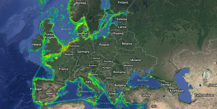
The European Marine Observation and Data Network (EMODnet) enables analysis of this impact by disseminating monthly information on vessel positions on a 1km by 1km grid. It distinguishes between vessel use - cargo, dredging or underwater operations, high-speed craft, fishing, military and law enforcement, passenger, pleasure craft, sailing, service, tanker, tug and towing, other, unknown.
The density maps are constructed from signals from vessels’ on-board automatic identification systems (AIS). This automatic tracking system uses transponders on ships to signal information on their nature and position to other ships and vessel traffic management information systems.
The signals are transmitted by VHF radio every 2 to 10 seconds depending on a vessel's speed while underway, and every 3 minutes while a vessel is at anchor. The system uses a Time Division Multiple Access (TDMA) radio access scheme to allocate time slots for the signals so that no two vessels within range are transmitting at the same time.
A ground network of receivers can pick up the signals in all Europe’s coastal zone up to about 40 nautical miles from the coast. Receivers mounted on an increasing number of earth orbiting satellites constitute a space-based system that extends the coverage to open seas. But whilst the Time Division Multiple Access (TDMA) radio access scheme ensures that no two ships within radio range of each other are transmitting at the same time, this is not the case for receivers on satellites. The TDMA defined in the AIS standard creates 4,500 available time-slots in each minute but this can be easily overwhelmed by the large satellite reception footprints and the increasing numbers of AIS transceivers, resulting in message collisions, which the satellite receiver cannot process. This means that a number of AIS-transmitting vessels become invisible.
The aim of this contract is to assess these errors by comparing results with other technologies
|
Lead contractor |
MARINTRAFIK OPEREISONS ANONYMI ETAIREIA PLIROFORIKIS |
|
Start Date |
20 August 2021 |
|
End Date |
20 May 2022 |
|
Contract value |
€185,000.00. |
If you have any questions, please get back to us through the form below

