This week, the European Commission, in close cooperation with the German Ministry of Education and Research, organised the event Mission ‘Restore our Ocean and Waters by 2030’: The Baltic and North Sea lighthouse in action on 25-26 April with the support of the BlueMissionBANOS Co-ordination and Support Action for the Baltic and North Sea. This event is part of a series of events that are launching Mission lighthouses for four sea and river basins—Danube & Black Sea, Baltic & North Sea, Mediterranean, and Atlantic-Arctic. The EU Mission ‘Restore our Ocean and Waters’ propagates the common aspiration to protect and restore the health of our ocean and waters through research and innovation, citizen engagement and blue investments. Mission lighthouses are research and innovation project portfolios, hubs for the development, demonstration and deployment of new solutions in major sea/river basins. They will leverage regional stakeholders’ engagement and help enhance political commitment across each of the regions. To this end, the Baltic & North Sea Basin lighthouse focuses on the objective to reach a carbon-neutral and sustainable circular blue economy.
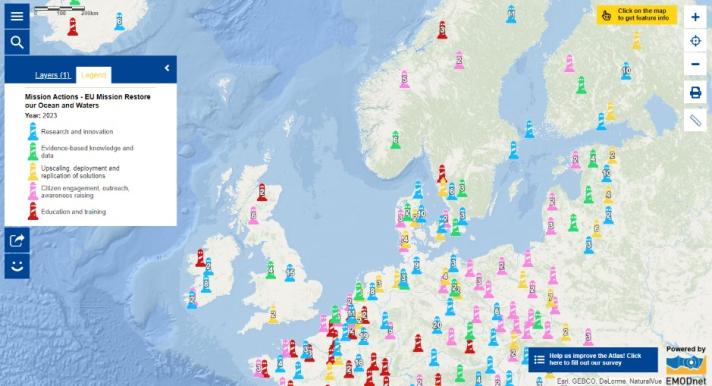
Have you seen that the map layer on Mission Actions in the European Atlas of the Seas has been updated? The number of actions submitted in the framework of the EU Mission ‘Restore our Ocean and Waters’ has significantly increased over the past months. The new version of the map layer includes the most recent contributions. Each of the lighthouses in the map represents an action pledged by a signatory of the Mission Charter. Click on the symbols to check what actions are already committed! Some lighthouses in the interactive map are indicated with numbers. This means there are several actions in this area. To see them, click on the arrows in the window that opens when you click on the lighthouse. The map layer increases the visibility of each pledged action, which could help to facilitate collaboration across institutions! The European Marine Observation and Data Network (EMODnet), who manages the European Atlas of the Seas, has submitted an action— Evolving marine data and knowledge services—in early 2023, committing to continuously delivering the access and provision of marine knowledge to underpin the core objectives of the EU Mission. Can you find EMODnet’s pledged action on the map (hint: the EMODnet Secretariat is based in Oostende in Belgium)?
What can you do?
- Do you have an action you would like to submit? Endorse the Mission Charter to support the EU Mission ‘Restore our Ocean and Water by 2030’ and, in future updates of the map layer, be sure to look for the lighthouse that represents your Mission Action!
- What is next? The European Commission, in close cooperation with the Italian government, the Sicily Region, and the University of Palermo, with the support of the BlueMissionMed Co-ordination and Support Action, will organise the event ‘The Mediterranean Lighthouse in Action’ on 30th May 2023. Register now to contribute to shaping the future for a Healthy, Pollution free Mediterranean basin!
The data in this map are provided by the European Commission.

